
Oklahoma's Geography
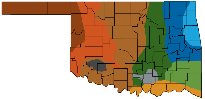
Oklahoma's 10 Geographical Regions
Oklahoma's geography ranges from arid plains to subtropical forests and mountains. Much of Oklahoma consists of level plains, but the state also has rugged hills and mountains covered by green forest. [1]
- Ozark Plateau (NE)
- Prairie Plains (NE - E)
- Ouachita Mountains (SE)
- Sandstone Hills (N - S)
- Arbuckle Mountains (SSE)
- Wichita Mountains (SSW)
- Red River Valley (S - SE)
- Red Beds Plains (N - S)
- Gypsum Hills (NW - SW)
- High Plains (NW)
Ozark Plateau
The Ozarks, also known as then Ozark Plateau or Ozark Mountains, spans the states of Missouri, Arkansas, Oklahoma and Kansas. In northeastern Oklahoma the Ozark Plateau region elevations range from about 650 to 1640 feet above sea level. The landscape is made up of rivers with steep valley walls separated by broad flat areas. [1][2][3]
Prairie Plains
The Prairie Plains lie west and south of the Ozark Plateau. Most of the state's coal and oil are produced here. Along with rich farmlands in the Arkansas River Valley. [1]
Sandstone Hills
The Sandstone Hills region extends south from the Kansas border to the Red River. This region is located in the north central part of Oklahoma. Early oil development was started in this region. The Sandstone Hills are from 250 to 400 feet high. [1]
Arbuckle Mountains
Situated in the heart of south-central Oklahoma, the Arbuckle Mountains were named in honor of Gen. Mathew Arbuckle, an early commander at Fort Gibson. The range's elevation decreases from the western edge, commonly 1,400 feet above sea level, to the eastern edge, around 700 feet. [6]
Wichita Mountains
The Wichita Mountains are named after the Wichita tribe. Located in southwestern Oklahoma, the Wichitas trend in a northwest-to-southeast direction and extend for approximately thirty miles. They comprise one of two locations in the state where igneous rocks are found above the earth's surface. The most common igneous rocks associated with the Wichita Mountains are granite, rhyolite, and gabbro. [7]
Red River Valley
The Red River Valley in southern Oklahoma along the Texas border is a rolling prairie known for its sandy and fertile soil with some forested hills. [1]
Red Beds Plains
The Red Beds Plains run from the Kansas border (north) and go south through the center of the state. The east has some forested areas and the west area is covered with grass. [1]
Gypsum Hills
The Gypsum Hills rise 150 to 200 feet and are capped with a 15 to 20 foot layer of gypsum. This region is west of the Red Beds Plains and runs north to the High Plains. [1]
High Plains
The High Plains are a region of level grasslands. They rise from 2,000 feet above sea level in the east to 4,973 feet above sea level in the west at the Black Mesa in the far northwest corner of the Oklahoma Panhandle. [1]
- eReference Desk: Geography and Landforms of Oklahoma
- Wikipeida: Ozarks
- Oklahoma Historical Society, Encyclopedia of Oklahoma: Ozark Plateau
- Wikipeida: Ouachita Mountains
- Oklahoma Historical Society, Encyclopedia of Oklahoma: Ouachita Mountains
- Oklahoma Historical Society, Encyclopedia of Oklahoma: Arbuckle Mountains
- Oklahoma Historical Society, Encyclopedia of Oklahoma: Wichita Mountains