
Grand
Grand
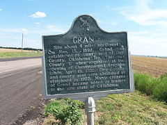
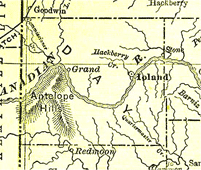
Site about 4 miles northwest. On Nov. 13 1892, Grand was established as county seat of Day County, Oklahoma Ter. This was County 'E' when organizers at the opening of Cheyenne and Arapaho lands April 19, 1892 Day County and county seat were abolished at statehood in 1907. Many citizens of Grand became noted as leaders in the new state of Oklahoma.
Location
Directions
Two miles west of U.S. Highway 283, at site of old Grand, ten miles south of Arnett, Ellis County.**
Regions
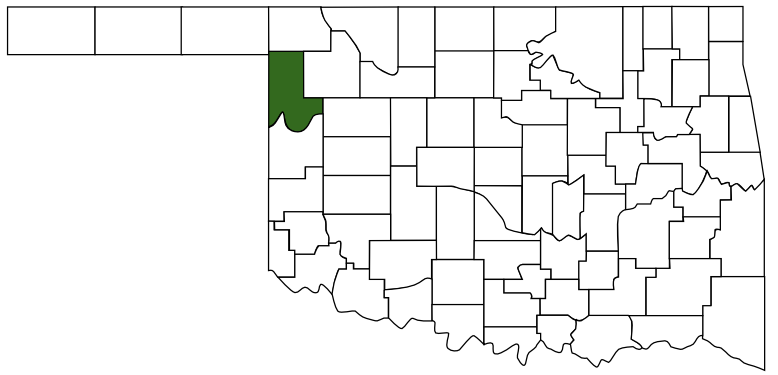 Ellis County
 Red Carpet Country
 Oklahoma
Maps
- 35.969440, -99.755890
- OpenStreetMap
- Google Maps
- Bing Maps
- Apple Maps
- MapQuest
Pictures
Notes
- Listed National Register of Historical Places
Grand Town Site ** (added 1972 - Site - #72001063)
14 mi. S of Arnett, Arnett
Historic Significance: Event
Area of Significance: Politics/Government
Period of Significance: 1875-1899, 1900-1924
Owner: Private
Historic Function: Domestic
Historic Sub-function: Village Site
Current Function: Landscape
Current Sub-function: Underwater - Grand history lives, thanks to one man
by Tom Lindley, Daily Oklahoman, Thursday July 21, 2005.GRAND - Like a lot of places, this once was a town with promises as big as its name. ...
- OKGenWeb: Day County, Oklahoma Territory 1892-1907
Day County, Oklahoma Territory was short lived from 1892 to 1907, though had eventful existance. The Courthouse burned, cattlemen dueled over water rights, there was lynching and feuding between free-grass and herd law proponents and tornado! By citizen's petition, 1907 legislators divided the county along the Canadian River, the north half merged with newly formed Ellis County, the south half became part of Roger Mills County.
- Encyclopedia of Oklahoma, Oklahoma Historical Society.
DAY COUNTY. Existing only for slightly more than fifteen years, through the Territorial Era until statehood on November 16, 1907, Day County was originally created as County E by act of Congress approved March 3, 1891. Bordering the Texas Panhandle, it lay within the Cheyenne and Arapaho lands that opened to non-Indian settlement on April 19, 1892. It was soon renamed Day County, for Charles Day, a contractor who built the courthouse at Ioland. Comprising thirty townships, the new entity was bisected by the meandering main Canadian River. The area’s most prominent geographical feature, the Antelope Hills, had been a landmark for both American Indians and for travelers on the California Road during the 1850s. ...
- Chronicles of Oklahoma
Volume 13, No. 2 June, 1935 OLD DAY COUNTY OKLAHOMA TERRITORYThe student of Oklahoma history may look in vain to find Day County, Oklahoma, on the map. However, there was at one time a Day County. From 1892 until 1907 it was a regularly organized county functioning as other counties. When Oklahoma became a state in 1907, Day County was eliminated. The convention that framed the Constitution created a number of new counties in that part of the State that constituted the Territory of Oklahoma, but only one was wiped off the map. Day County was situated in the northwest corner of the Cheyenne and Arapahoe country and the county seat was Grand, a frontier village located on the north bank of the South Canadian river. ...
- 1895 U.S. Atlas - Day County
- BlogOklahoma.us: California Road
** FortTours.com: Grand
Location of Marker: Two miles west of U.S. Highway 283, at site of old Grand, ten miles south of Arnett, Ellis County.
Mark of Heritage, by Muriel H. Wright, courtesy of Oklahoma Historical Society. ...